Part One: The Original Map
Ever since I first heard the term in third grade Georgia history, I’ve been intrigued by the phrase “The Margravate of Azilia.” The sound of it. Hear it? Say it slowly. Isn’t it beautiful? Especially the way my Georgia teacher said it, with her native soft r’s, the slow, extended unfurling of “Azilia.” Later, in high school, my closest pals and I took to using the phrase as our calming mantra as we struggled with 1960s-era dangers so close to us – the war in VietNam, the struggles for Civil Rights … Sort of like our own private om.
Beyond the linguistic appeal the phrase held for me, I’ve also been interested in the concept behind the phrase, the paternal side of my family having been among the very earliest settlers of Georgia. Here’s more on that concept:
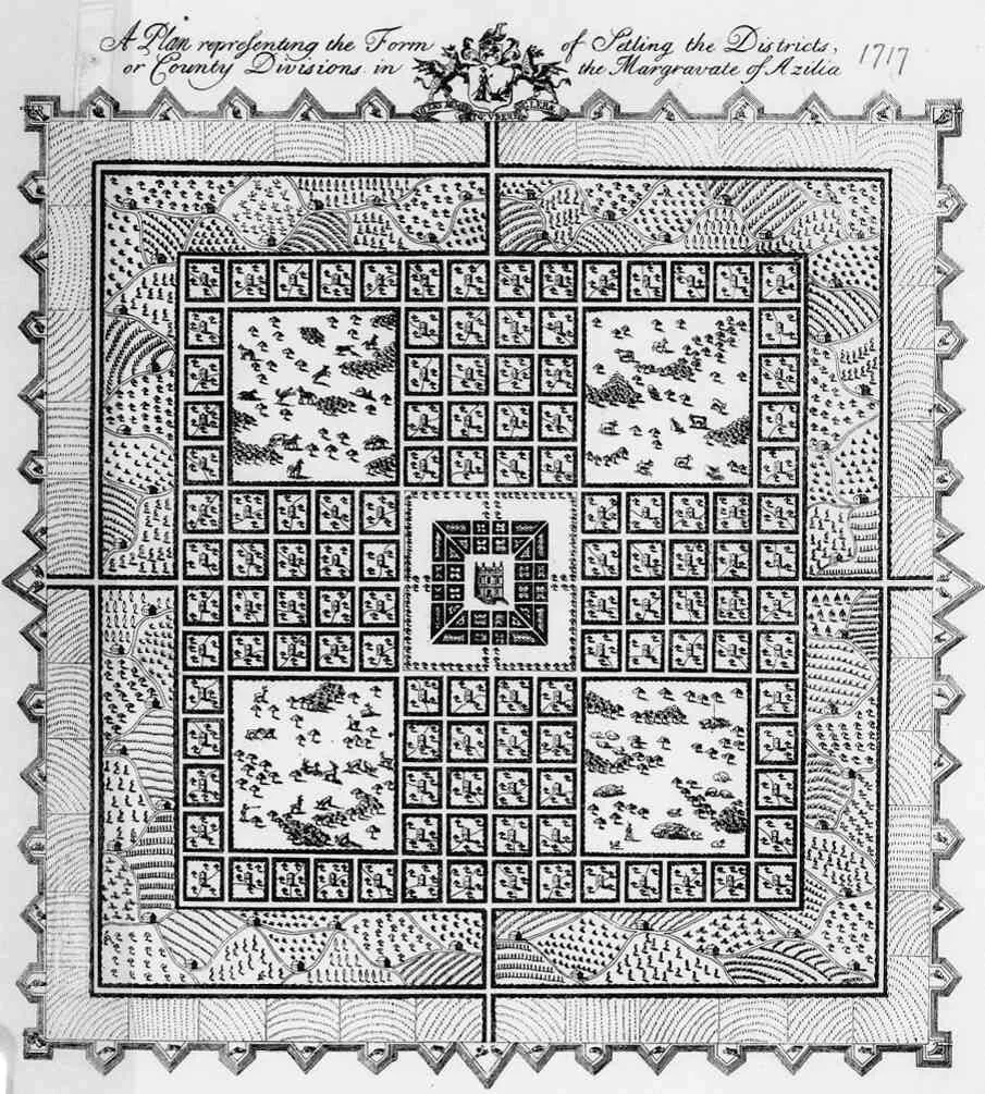
In 1717, sixteen years before Georgia was founded, Sir Robert Montgomery proposed the creation of the Margravate of Azilia. Today the proposal is best known because of an illustration of the colony created at the time, believed to be the earliest example of American art created by western land speculation.
…
Montgomery proposed a colony of some 400 square miles between the Savannah River and the Alatamaha [sic] River in a tract entitled "A Discourse concerning the design'd establishment of a New Colony to the South of Carolina, in the most delightful country of the Universe. By Sir Robert Mountgomry, Baronet." The "tract" is somewhat of a prospectus for the project. A margravate is an eastern European name for a small colony whose leader is a "margrave," (ruler) normally with some form of lineage; Azilia is a Mesolithic European culture. The map that accompanied the tract was an impressive piece of work and probably served as the prototype for other similar ventures. Each twenty-square mile box represents a district or township.
…
In the center of the Margravate of Azilia a city "three miles square" with the palace of the Margrave at the center. Around the city "a void," as described by Montgomry, sort of a green space, of a mile. The ambitious plan called for a grant from Lord Carteret the Lord Palatine, and the Lords Proprietors of the Province of Carolina. In exchange the new colony would pay a penny sterling for each acre of land. (There are 256,000 acres in 400 sq. miles).
After the green space around the city came the homes of the gentry, the landed class. In each quadrant is an area of 25 square miles of "great Parks." One contains horses, one cows, one sheep, and the fourth contains deer. Hunting is portrayed in the area with the deer.
Outside the noble's estates were farms to be worked by commoners, who after a number of years of service to the Margrave would recieve title to the land. Finally, the land of the Margrave himself. On the outside of the square a defensive, walled parameter of eighty miles would be established.
Inhabitants of the colony, as envisioned by Montgomery, would be indentured from England's poorer classes. They would serve as both citizens and soldiers, when needed, to protect the colony from the French, the Spanish or the Indians. Overseeing this citizen army and the society as a whole would be the landed gentry.
Montgomery's idea was never more than a plan.
Source of text: http://www.ourgeorgiahistory.com/early/azilia.html
Source of image: https://georgiainfo.galileo.usg.edu/topics/history/article/fdrs.../margravate-of-azilia-map-1717
The failure of Sir Montgomery’s plan is understandable. I mean, who in the world would want to go out into the wilderness, family in tow, with the primary purpose of serving as a buffer for some rich guy?
Okay – You get the idea here. And you can read much more about the Margravate of Azilia if you Google.
The Hargett Rare Book and Manuscript Library at the University of Georgia owns several copies of the map. I plan to go lay my eyes on them.